Timberdrone
Timberdrone
  • Home
  • Services
    • Forestry
    • Real Estate
    • Search and Rescue
  • Staff
  • Drone Fleet
  • Contact Us
  • DroneDeploy
  • More
    • Home
    • Services
      • Forestry
      • Real Estate
      • Search and Rescue
    • Staff
    • Drone Fleet
    • Contact Us
    • DroneDeploy

  • Home
  • Services
  • Staff
  • Drone Fleet
  • Contact Us
  • DroneDeploy

Using Drones for Forestry Applications

Free to Grow Surveys

Harvest Unit Depletions

Harvest Unit Depletions

TimberDrone uses state of the art drones flying at low elevation with high resolution cameras capable of producing resolutions under 1".

Find out more

Harvest Unit Depletions

Harvest Unit Depletions

Harvest Unit Depletions

drone forestry depletion orthophoto

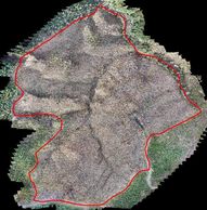
TimberDrone creates timely ortho-corrected imagery that can be used in your GIS to update harvest unit boundaries.

Find out more

Stockpile Reports

Harvest Unit Depletions

Stockpile Reports

TimberDrone allows foresters to  calculate stockpile dimensions and volumes by using drone imagery to create 3D models.

Find out more

3D Modeling

Silviculture Treatment

Stockpile Reports

drone forestry 3D modeling

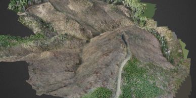
 TimberDrone collects images from multiple angles and uses specialized image processing software to create orthophotos and 3D models.

Find out more

Silviculture Treatment

Silviculture Treatment

Silviculture Treatment

drone forestry orthophoto

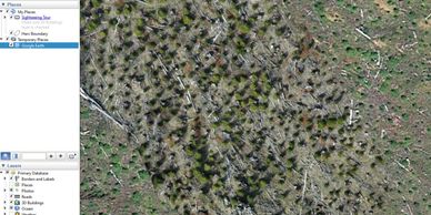
TimberDrone produces high resolution georeferenced orthophotos that can be viewed in ArcGIS or Google Earth for use in evaluating silvicultural treatments.

Find out more

Video

Silviculture Treatment

Silviculture Treatment

drone forestry

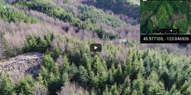
TimberDrone will deliver up to 4K video quality flown at very low elevations with our drones to capture amazing video for use in evaluating plantations of any age.

Find out more

Autonomous Tree Counting

 TimberDrone uses a cloud-based service to count the trees across an entire stand autonomously.  A point shapefile is generated which can be used to generate custom reports.  This is ideal for 5th year surveys as well as post PCT audits.

5th Year Survey Fishnet (pdf)Download
5th Year Survey Tree Count Heat Map (pdf)Download
5th Year Survey Tree Location (pdf)Download
Post PCT Fishnet (pdf)Download
Post PCT Tree Locations (pdf)Download
Post PCT TPA Heat Map (pdf)Download
TIMBERDRONE - MODIFIED 5TH YEAR SURVEYS USING DRONE IMAGERY (pdf)Download

Social

Copyright © 2018 TimberDrone - All Rights Reserved.